STUDIO MAPPING THE URBAN MINE
Prof. Giovanni Betti, LB Anna Bajanova, WM Christian Schmidts, T Angely Angulo Meza
Weekly meetings at the studio (room 314)
Wednesdays 2 pm - 6 pm
First date: 16th October 2024 at 2 pm
Mapping the Urban Mine
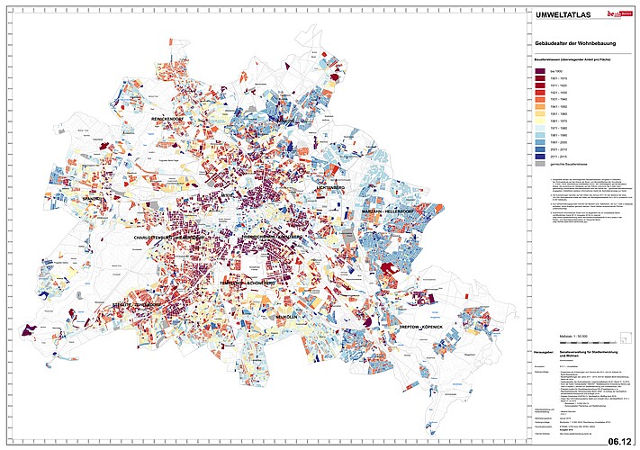
This winter semester, our design studio titled "Mapping the Urban Mine" will explore Berlin's existing building stock through a research-oriented lens, combining GIS and parametric modeling. The focus will be on analyzing "ordinary" buildings—those not historically listed or recently built, but forming the backbone of Berlin’s urban fabric. By studying these structures, the studio aims to uncover their material potential and imagine how they could contribute to more sustainable urban development.
Studio Structure
The studio is structured in five key phases. The first part of the semester (Phases 1-4) will focus on research, analysis, and parametric modeling, while the second half (Phase 5) will prioritize design exploration. Here, students will move beyond analysis to develop innovative design proposals using the materials and buildings they’ve studied, transforming these findings into visionary yet grounded architectural projects.
Phase 1-4: Research and Modeling (First Half of the Semester)
The first four phases form the analytical foundation of the studio and will take up the initial half of the semester. The work done in these phases will directly feed into the more design-driven explorations that follow.
Phase 1: Typology and Timeframe Selection
In the first phase, students will choose a specific building typology—residential, commercial, or industrial—along with a timeframe from three key periods: pre-1919, 1919-1945, 1945-1989, and post-1989. This approach allows us to focus on standard, "everyday" buildings, which are often overlooked but vital for understanding common construction methods and their potential reuse.
Phase 2: GIS Analysis and Archival Research
Once a typology and timeframe have been selected, students will use GIS mapping tools to identify relevant buildings across Berlin. In parallel, they will conduct archival research to understand the structural systems, materials, and layouts used in these buildings. This phase will result in detailed architectural drawings (plans and sections) that capture the key characteristics of each building type.
Phase 3: Parametric Modeling
In the third phase, students will translate their research into parametric models using Rhino and Grasshopper. These models will serve as tools for estimating the material quantities embedded in Berlin’s building stock and calculating the embodied CO2 for each structure. The aim here is not to recreate each building exactly, but to create a framework that allows for a broader understanding of the city's material "inventory."
Phase 4: Data Visualization and Analysis
Next, students will aggregate their findings to create data visualizations that illustrate the types and quantities of materials found in the city’s buildings, as well as their associated CO2 emissions. These visualizations will provide a city-wide perspective on Berlin’s "urban mine," highlighting the potential for material reuse in sustainable urban planning.
Phase 5: Reimagining Berlin’s Building Stock (Second Half of the Semester)
The reflections on the city and its materiality conducted during the semester will form the basis for the final design explorations. How can the buildings that have been studied be partially or fully deconstructed, reassembled or extended? How can their reclaimed materials be used for new architectural projects that address contemporary urban needs, such as housing or public spaces? The focus will be on circular design strategies, where waste is minimized and materials are reused in line with sustainability principles.